

Sajad Jamshidi
Climate change impact assessments, Vegetation and Crop Dynamics in Changing Climates,Geospatial Analysis of Land Surface Processes
Video from NASA Goddard

Sajad Jamshidi
Purdue University
my cv

google scholar
Email me

ABOUT ME
I hold a Ph.D. in water sciences and proudly serve as a research scientist at Purdue University working with Dr. Wang (www.dianewanglab.com). My expertise lies at the intersection of agriculture, hydrology, and water science, where I am dedicated to unraveling complex water-related challenges.
I employ a diverse range of data sources, spanning from satellite observations and outputs of climate models to historical observational records. This comprehensive dataset is integrated with cutting-edge tools such as machine learning algorithms, crop models, and land surface models. My investigative approach is further enriched by the application of geospatial analysis and advanced statistical techniques. Through this multidimensional framework, I unveil the intricate repercussions of climate extremes on vital elements such as crops, vegetation, and water resources. Moreover, I undertake a thorough assessment to ascertain the future implications on food and water security.
My overarching research objective revolves around enhancing the predictability of climate extreme impacts while safeguarding the future's food and water security.
Within my current portfolio, you will find a snapshot of ongoing projects and recent scholarly endeavors. For a deeper exploration of my academic endeavors, replete with insights from my published works, I invite you to peruse my comprehensive CV.
Developing machine learning models to predict rice yield under future climate
Global crop production under future climate scenarios


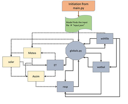
Developing a generic crop model in Python
Drought shift over the U.S. using a century of SPEI data

Simulating a heatwave event over Europe using a more detailed land USE map
Identifying how rainfall variability propagates to agricultural systems using satellite-based data


Accuracy assessments of Satelite and model driven Soil moisture products during a hurricane
Identifying Multivariate Drivers of Soil Moisture Variability

